
Before we start
Why this booklet?
In the first booklet I looked at when a video was filmed. This time the question is different: where?
One of the videos that spread after the 20 April 2026 Sanriku earthquake was a tsunami clip in which the water sweeps across a car park. The posts presented it as that day’s tsunami. Fact checkers soon showed that the footage was from 2011.
I took one step further and found the roof of the building it was filmed from. I used only pages anyone can open: frames of the video itself, aerial photos from GSI, Japan’s official mapping agency, OpenStreetMap records and a few calculations from coordinates. At each step I write down what I looked at, what I measured and what I could not know.
The event
11 March 2011
First I noted the event the footage belongs to, from an official source. I re-read the values on 29 September 2026 in the report the Japan Meteorological Agency (JMA) published for this earthquake.
| Record | |
|---|---|
| Date and time | 11 March 2011, 14:46 Japan time |
| Place | Off Sanriku, Pacific Ocean |
| Magnitude | M 9.0 (JMA) |
| Highest wave in Ishinomaki | 8.6 m or higher, at 15:26, Ayukawa gauge |
The claim
What was shared in 2026?
In the days after the earthquake the video started to spread again. According to AAP FactCheck’s article of 29 April 2026, a Brisbane-based Facebook account shared it as “the real tsunami not AI” after the magnitude 7.5 earthquake of the previous Monday.
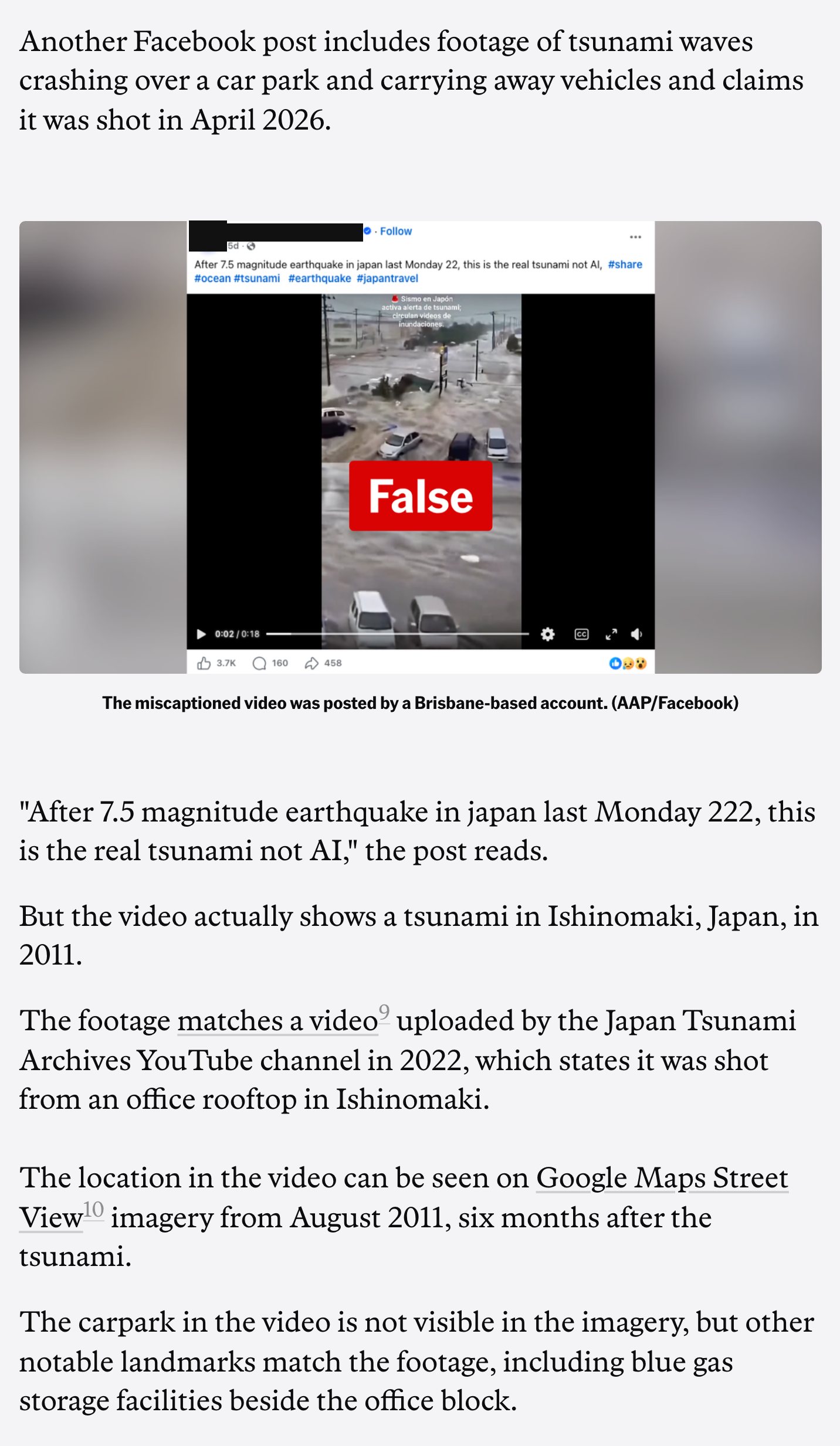
AAP FactCheck, 29 April 2026. 1: the text of the post, 2: where AAP placed the video, 3: the structure they matched, the blue gas storage. The account’s name and picture are blacked out. Screenshot taken on 29 September 2026.
SHA-256 1c3069c1cc5bOpen full sizeThe sharing account’s name, The sharing account’s picture: blacked out
Step 1
Put the question in one sentence
From the roof of which building was this filmed?
The fact checkers had already found the date. My question was about the place, and the answer had to be a coordinate. A district name or a description such as “near the port” does not answer it.
I also wrote down in advance when I would call it settled: when at least three independent clues point to the same building. A single address or a single resemblance is not enough.
Step 2
Read the description, but do not trust it
Searching YouTube for 石巻 津波 (Ishinomaki tsunami) brought up many copies of the same footage. The oldest copy I found was uploaded on 18 December 2011, and its description gives an address.
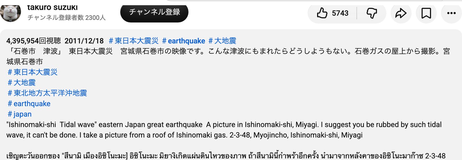
The takuro suzuki channel, YouTube. 1: uploaded 18 December 2011, 2: the address in the description, Myojincho 2-3-48. Screenshot taken on 29 September 2026.
SHA-256 cb7666252b4cOpen full size
The Japanese broadcaster FNN published the same footage on its archive channel on 25 October 2012 and wrote far more detail in the description: the building, the road in front of it and the distance to a school.
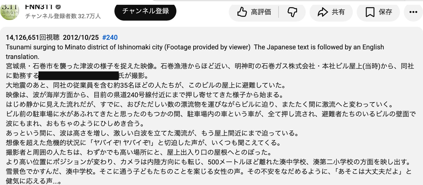
FNN311, YouTube. 1: uploaded 25 October 2012, 2: where it was filmed, the roof of Ishinomaki Gas’s head office building in Myojincho (at the time), 3: the road in front, Prefectural Road 240, 4: distance to the school, about 500 m. The filmer’s name is blacked out. Screenshot taken on 29 September 2026.
SHA-256 2973341a1c07Open full sizeThe name of the person who filmed: blacked out
Step 3
Pick the things that do not move
The water, the cars and the debris are gone the next day. I was looking for structures that would still stand in the same place years later. I paused the video every six seconds and took 45 frames, set aside the frames showing people, and noted this in the rest:
0:20, looking south. A car park with painted lines right in front, a wide road lined with power poles behind it, and at the back a row of pines and white factory buildings.
3:16, looking west. Two green spheres inside lattice frames and three or four tall, thin turquoise tanks. The thin tanks are closer than the spheres and to their right.
2:50 and 3:10. A wide green corrugated roof right below the camera. At 3:10 FNN itself marked the distant buildings with an orange frame.
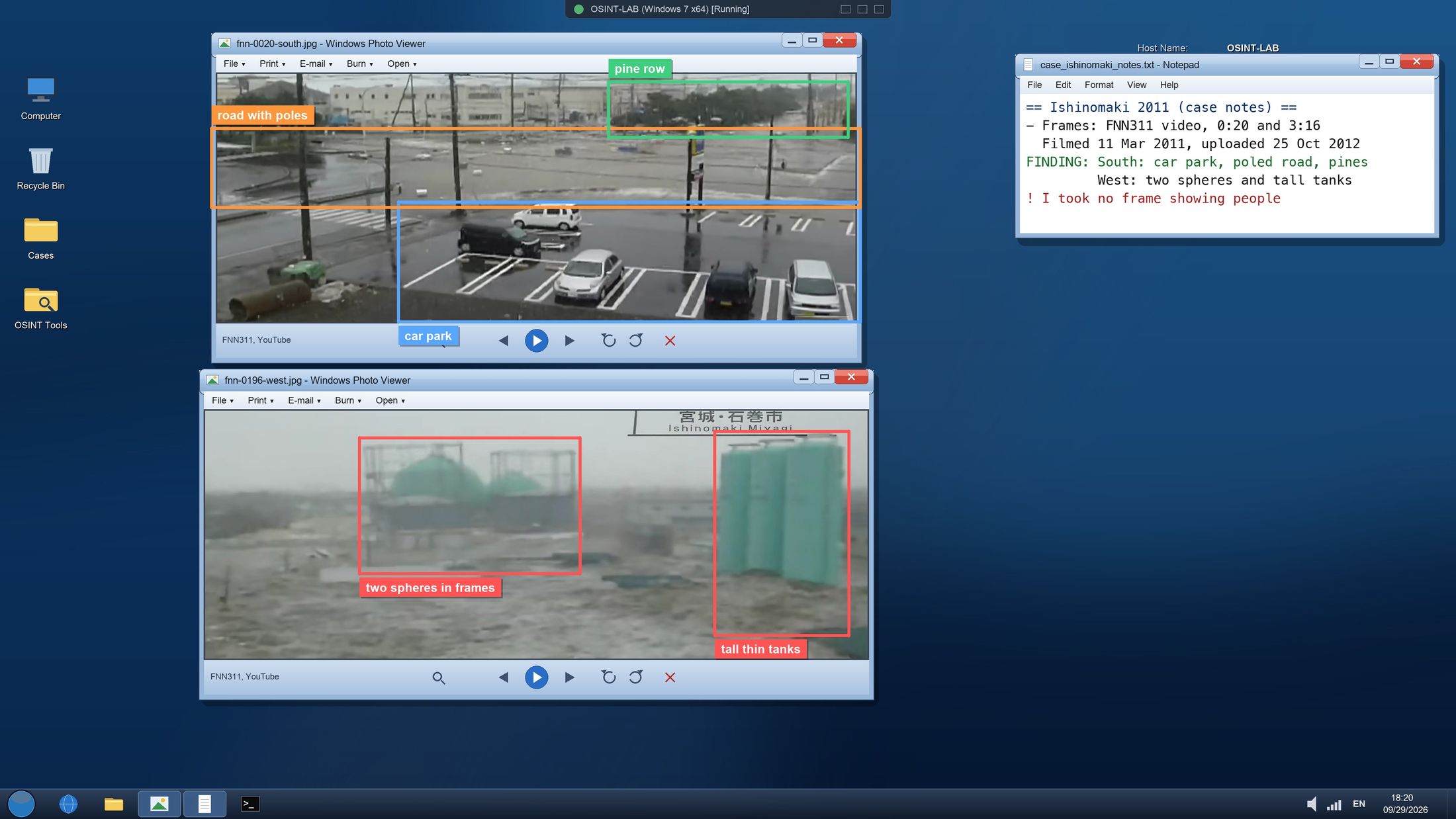
Work screen 1. Top, the frame at 0:20 looking south: car park, road with poles, row of pines. Bottom, the frame at 3:16 looking west: two spheres in frames and tall thin tanks. Frames taken from the paused player on 29 September 2026
SHA-256 db39b67f774aOpen full size
Step 4
Put the address on a map
I typed the address into GSI’s map service. The search gave a point, but it fell at the edge of a road. Address points often mark the rough place of a plot or a block rather than a building.
OpenStreetMap has a record named 石巻ガス (Ishinomaki Gas) in the same district, and its point sits inside a large building. GSI’s address point is about 85 m away from it.
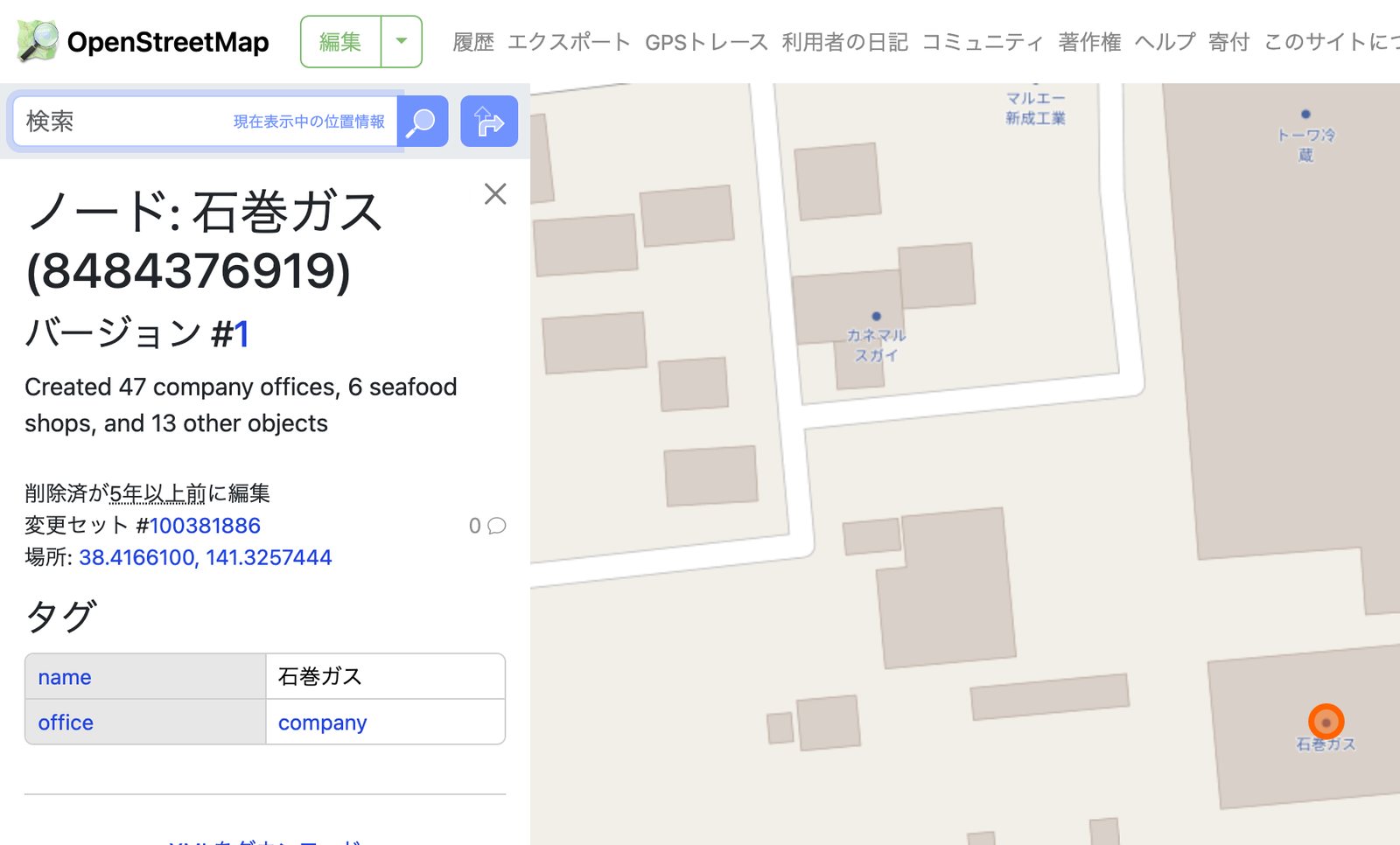
OpenStreetMap, node 8484376919. 1: the record’s name, 2: its latitude. Map data © OpenStreetMap contributors. Screenshot taken on 29 September 2026.
SHA-256 4bbce468b9f6Cropped as in the PDFOpen full size
That left two candidates: the address point and the OSM record. The structures in the video would decide between them.
Step 5
Measure directions and distances
In the current aerial photo the two large gas tanks stand west of the OSM record. The frame at 3:16 shows the tanks while looking west. In that frame the thin tanks are closer than the spheres, and in the aerial photo those small tanks sit between the spheres and the building.
I computed the distances from the OSM coordinates. The tanks are 172 m from the building, and the centre point of Minato Junior High School in OSM is 387 m away. Prefectural Road 240 runs east to west about 100 m south of the building. It is the wide road seen behind the car park in the frame at 0:20, looking south.
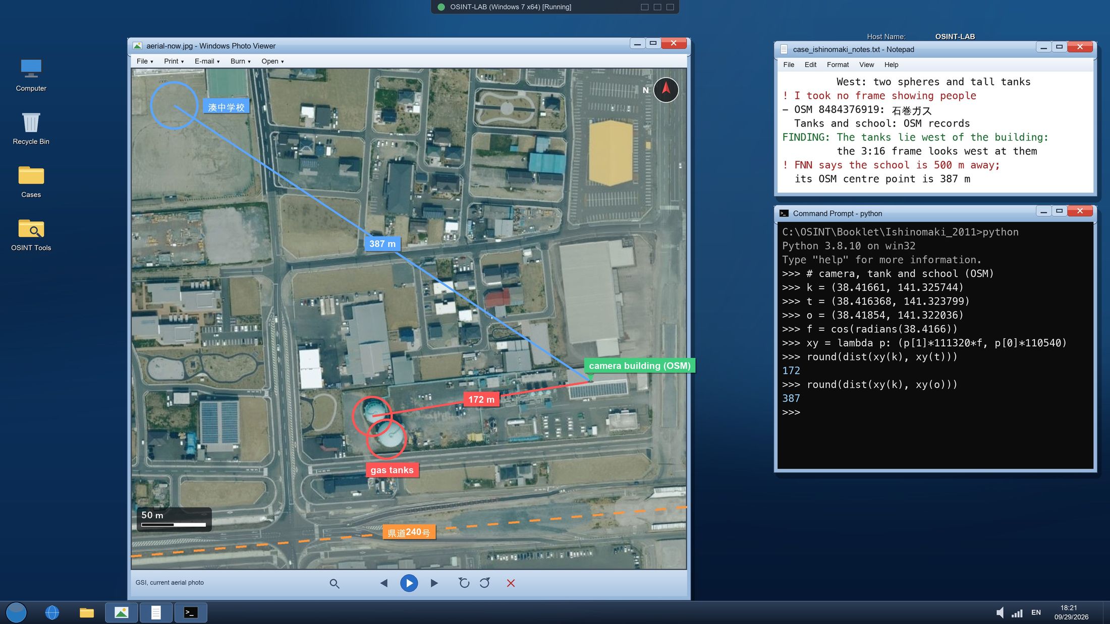
Work screen 2. GSI’s current aerial photo with the camera building (OSM), the gas tanks, Minato Junior High School and Prefectural Road 240. The Python session on the right computes the distances from the OSM coordinates and was really run when the screen was drawn
SHA-256 0aa521041ba1Open full size
Step 6
Compare with the 2011 photo
Today’s photo is not enough on its own: much can change in fifteen years. I opened GSI’s aerial photos taken on 12 and 13 March 2011, the day after the tsunami.
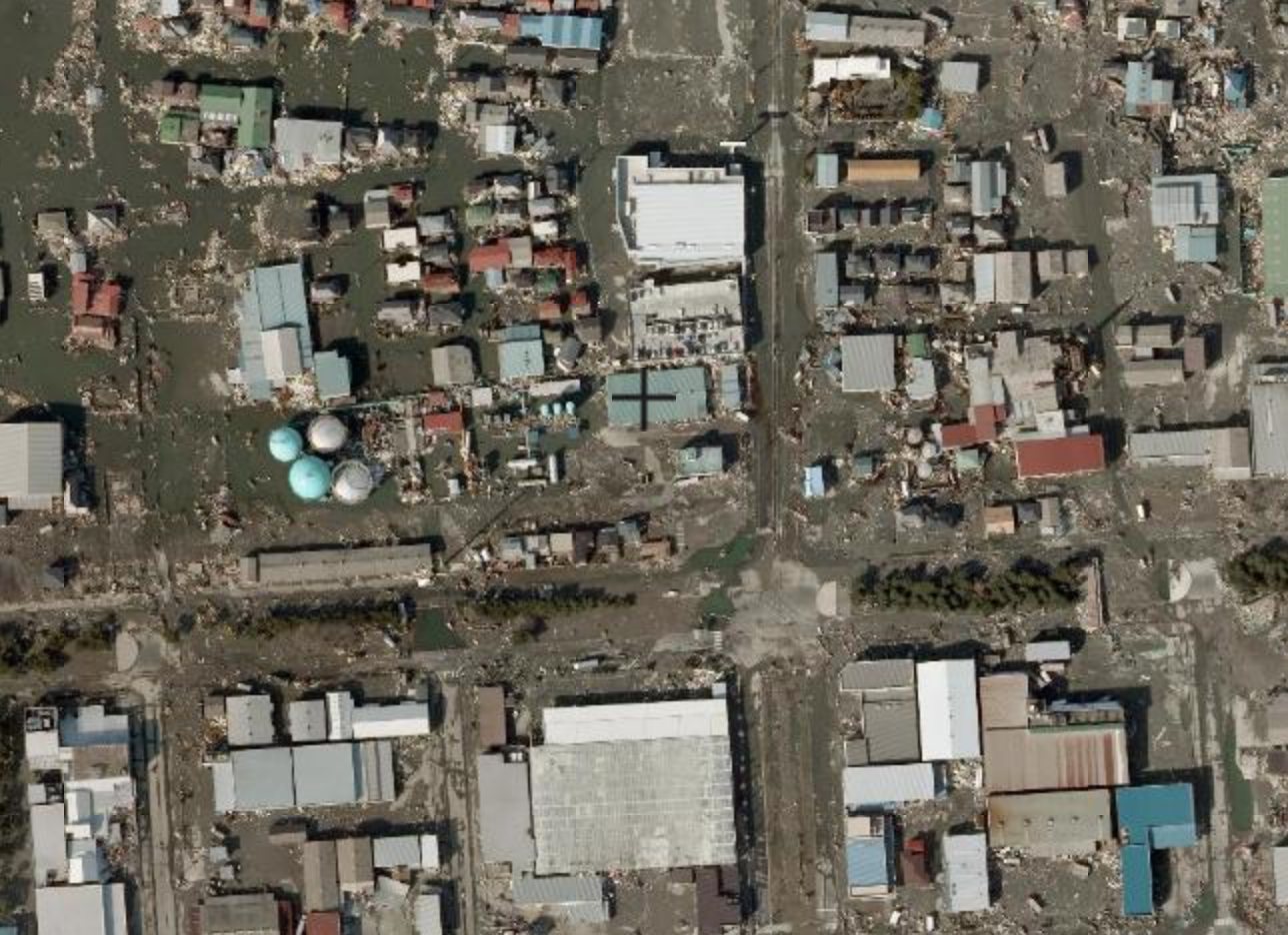
GSI map service, the 東日本大震災後正射画像 layer, 12 and 13 March 2011. 1: four round structures, 2: the centre of the map, the building in OSM. Source: GSI (出典 国土地理院). Screenshot taken on 29 September 2026.
SHA-256 a81ca2430a15Cropped as in the PDFOpen full size
The 2011 photo shows four round structures, two turquoise and two grey. Today only the two turquoise tanks remain. The camera building’s roof is green in 2011, the same as the green corrugated roof right below the camera in the frames at 2:50 and 3:10. Today the same roof carries solar panels.
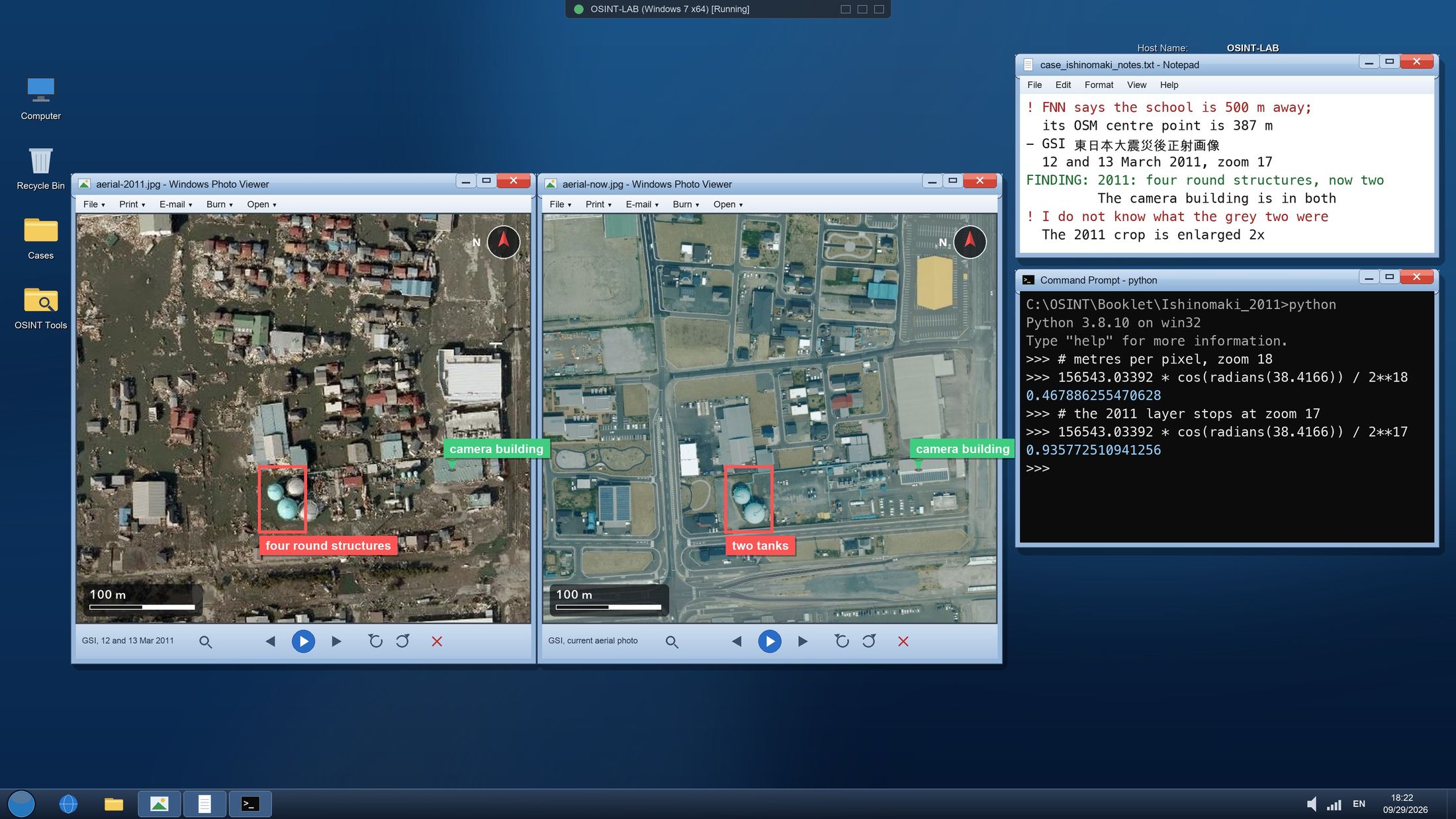
Work screen 3. The same area, 12 and 13 March 2011 on the left, today on the right. Two of the four round structures remain, and the camera building is there in both. The 2011 photo is enlarged 2x so both crops share one scale
SHA-256 7c875f68f70eOpen full size
In the video the same roof shows at 3:10, right below the camera.
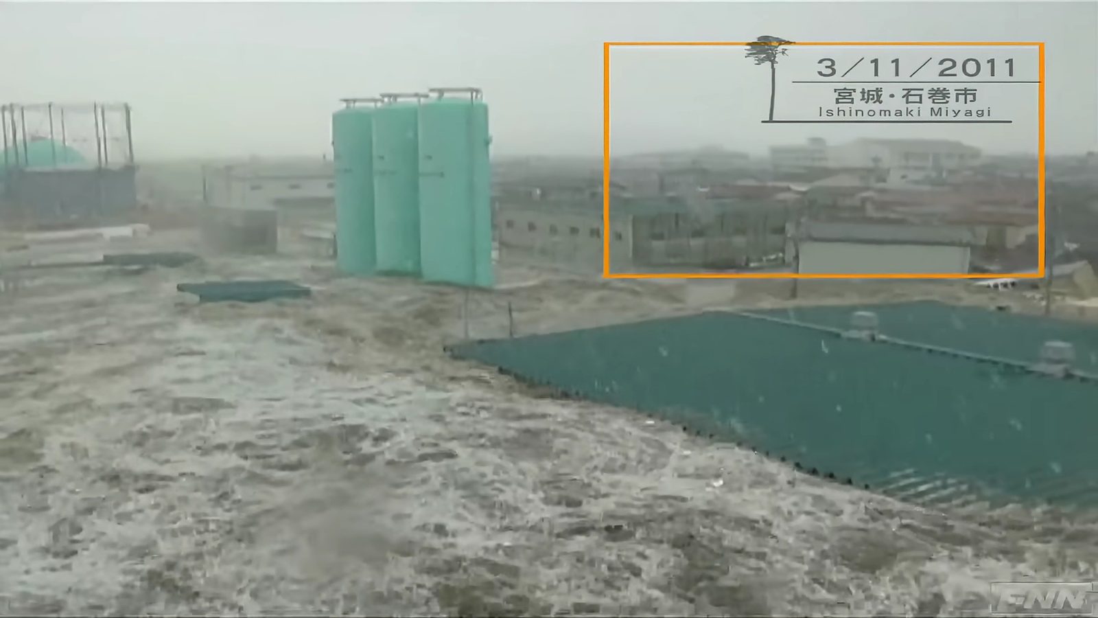
FNN311 video, 3:10. The green corrugated roof below the camera, the tall thin tanks behind. The orange frame is FNN’s own mark. Screenshot taken on 29 September 2026.
SHA-256 e919643bc491Open full size
Comparison
What did others find?
After reaching my own result I read what the fact checkers wrote. AAP matched the place with Google Street View imagery from August 2011 and with the blue gas storage next to the office block. Tempo also confirmed through a visual match on Google Maps that the video was filmed at a gas company in Ishinomaki.
My route was different: instead of Street View I used GSI’s 2011 aerial photos, OSM records and distances from coordinates. Both routes lead to the same building.
Conclusion
Where I ended up
The video was filmed on 11 March 2011 from the roof of the Ishinomaki Gas building in Myojincho, in Ishinomaki’s Minato district. In OpenStreetMap the building is recorded as 石巻ガス at 38.41661 N, 141.32574 E.
| What the evidence shows | What it does not show |
|---|---|
| The tanks are 172 m west; the video shows them while looking west. | The minute the video was filmed. |
| The road is about 100 m south; the frame looking south shows the car park and the road. | What the two grey structures of 2011 were. |
| In 2011, a green roof and four round structures, as in the video. | Where the 21SEIKI car park FNN mentions is today. |
| The oldest copy I found is dated 18 December 2011. | Why people shared it in 2026. |
Three independent clues point to the same building: the tanks to the west, the road and car park to the south, and the green roof of 2011. By the rule I set at the start, the location is settled.
Your turn
If you want to try it yourself
Next time someone sends you a video asking “where is this?”, try these six steps.
1. Turn the question into one sentence whose answer is a coordinate.
2. Treat the address in the description as a candidate, not as evidence.
3. Pick the structures in the video that will stay put for years. Do not use frames showing people.
4. Find the candidate on an official map and in OpenStreetMap, and compute directions and distances.
5. Compare with the aerial photo closest to the date of the event.
6. If at least three independent clues do not point to the same spot, write “I don’t know”.
Sources
Where I looked
- 1. Japan Meteorological Agency (JMA), 災害時地震・津波速報 平成23年(2011年)東北地方太平洋沖地震 (quick report on the 2011 Tohoku earthquake). jma.go.jp/jma/kishou/books/saigaiji/saigaiji_201101/saigaiji_201101_01.pdf
- 2. takuro suzuki, YouTube, 18 December 2011. youtube.com/watch?v=aAIj2fws5O4
- 3. FNN311, YouTube, 25 October 2012, 石巻市湊地区に押し寄せる津波【視聴者提供映像】. youtube.com/watch?v=K0rWPm9f3GQ
- 4. AAP FactCheck, “Old Japan disaster videos recycled after recent earthquake”, 29 April 2026. aap.com.au/factcheck/old-japan-disaster-videos-recycled-after-recent-earthquake
- 5. Tempo, “Fact Check: Misleading Videos Circulate After April 20, 2026 Japan Earthquake”, 27 April 2026. en.tempo.co/read/2100617
- 6. Geospatial Information Authority of Japan (GSI), map service and tiles: current aerial photos (seamlessphoto), 東日本大震災後正射画像 (toho1, 12 and 13 March 2011), standard map. maps.gsi.go.jp. Source: GSI (出典 国土地理院)
- 7. OpenStreetMap, node 8484376919 (石巻ガス), ways 104429351 and 104429356 (gas tanks), 903069337 (石巻市立湊中学校), 941860082 and 941860085 (県道240号 石巻女川線). © OpenStreetMap contributors, ODbL
- Every source was checked again on 29 September 2026.
Trail
Dead ends, conflicts and open questions
Dead ends
1
Ayukawa time
Rejected
- Tested
- Does the Ayukawa gauge record give the time of the video?
- Why it was dropped
- The gauge is on the Oshika Peninsula, not in Minato where the video was filmed. No official arrival time for Minato was found.
- Evidence that dropped it
- Sources
- Effect on the result
- None The video’s time was not guessed and stays an open question.
- Lesson in method
- Check where a measurement was taken. The same city is not the same place.
2
Address alone
Rejected
- Tested
- Does the address in the video description prove the place on its own?
- Why it was dropped
- Whoever uploads a video writes its description. It can be wrong, or copied from another video.
- Evidence that dropped it
- Effect on the result
- None The address stayed a candidate. The result rests on the structures in the footage.
- Lesson in method
- Treat the address in the description as a candidate, not as evidence.
3
GSI address point
Rejected
- Tested
- Does GSI’s address search give the building the camera stood on?
- Why it was dropped
- The point fell at the edge of a road, about 85 m from the 石巻ガス record in OSM.
- Evidence that dropped it
- Measurements 85 m, From the GSI address point to the OSM record
- Sources
- Effect on the result
- None The OSM record was used for the camera position, and the structures in the video supported it.
- Lesson in method
- Address points often mark the rough place of a plot or a block rather than a building.
4
Today’s photo alone
Rejected
- Tested
- Is today’s aerial photo enough on its own to compare with the video?
- Why it was dropped
- The 2011 photo shows four round structures, today two. The roof changed too: green then, solar panels now.
- Evidence that dropped it
- Effect on the result
- Changed the result Looking at the 2011 photo gave the third clue, the green roof.
- Lesson in method
- Compare with the aerial photo closest to the date of the event.
5
21SEIKI candidate
Set aside
- Tested
- Is today’s pachinko hall about 470 m north of the building the 21SEIKI that FNN mentions?
- Why it was dropped
- OSM has no record named 21SEIKI, and the hall could not be confirmed as the same place.
- Evidence that dropped it
- Measurements 470 m, From the camera building to today’s pachinko hall
- Effect on the result
- None Left out of the result; it stays an open question.
- Lesson in method
- Leave a clue you cannot confirm out of the result, and say so.
Conflicts
1
Where the camera building is
| GSI address search | OpenStreetMap node 8484376919 | |
|---|---|---|
| Value | A point at the edge of a road | 38.41661 N, 141.32574 E, inside a large building |
| Method | The address from the description, typed into GSI’s map service. | The OSM record named 石巻ガス. |
| Sources | Geospatial Information Authority of Japan (GSI) | OpenStreetMap |
- Possible explanation
- The two records are about 85 m apart. Address points often mark the rough place of a plot or a block.
- Effect on the result
- None The structures supported the OSM record; the address point was not used as the camera position.
2
Distance to the school
| FNN, video description | Measurement from coordinates | |
|---|---|---|
| Value | about 500 m | 387 m |
| Method | How it was measured is not stated. | From the building’s OSM point to the centre point of the school grounds in OSM. |
| Sources | FNN311 (YouTube) | From the camera building to the centre point of Minato Junior High School |
- Possible explanation
- The school grounds are large. FNN may have meant one of its buildings where this file took the centre of the grounds.
- Effect on the result
- None The difference does not change the result. The direction and the other two clues point to the same building.
Open questions
Versions
- 1.0 29 September 2026 First edition, Turkish and English, 17 pages.